The City of Brea's Tongva Village
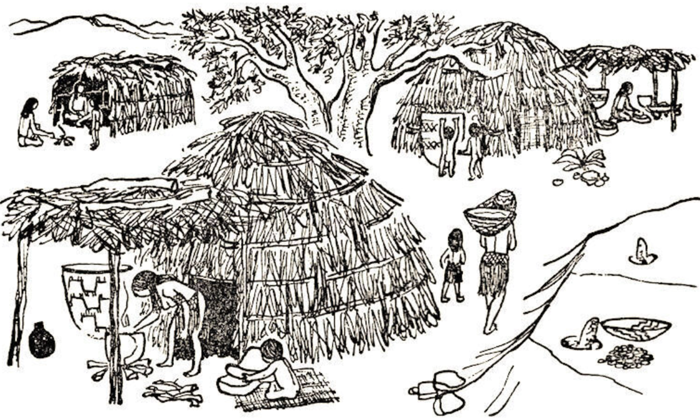
A Southern California Indigenous Village. Courtesy of Phil Brigandi, OC Historyland
The city of Brea, California was once home to a Tongva village. This village was inhabited prior to the arrival of Spanish colonists in 1769. New research sheds light on this village’s name, location, and individuals who lived within it.
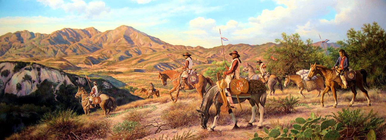
A highly stylized portrayal of the Portolá Expedition. While not entirely historically accurate, this beautiful mural still gives a very general impression of the kinds of Spanish leather-jacket soldiers that passed by the village on Brea Creek in 1769. "Discovering Orange County" - A mural by Robert Evans (2010) (Courtesy the City of Laguna Hills)
The first overland Spanish expedition to today’s California occurred in 1769 under the command of Gaspar Portolá. The expedition consisted of dozens of soldiers, mule drivers, a small number of officers, and two Franciscan missionaries. It departed from San Diego on July 14 and headed north in search of the bay of Monterey, which had been promoted as a possible colony since Sebastian Vizcaino’s exploring expedition there in 1602. On July 27, 1769, the Portolá Expedition reached the Santa Ana River near the intersection of today’s 91 and 55 Freeways. There it encountered a large Tongva village. When Mission San Gabriel was later established in 1771, an individual was recorded in the mission’s baptismal register as being from “the village on the Santa Ana River on the road to Monterey.” This description indicates that the village was almost certainly the same encountered by the Portolá Expedition (all information pertaining to the Portola Expedition in Orange County can be found in the book The Portola Expedition in Orange County 1769-2019 by Phil Brigandi and Eric Plunkett. Further information can be found in the article “Tracing the Trail of the Portola Expedition in Orange County” by Eric Plunkett). The village’s name in the baptismal register was Hutuuknga (spelled in a variety of ways in the mission registers, but pronounced hoot-uk-nga and standardized by the Early California Cultural Atlas as “Hutuuknga”).
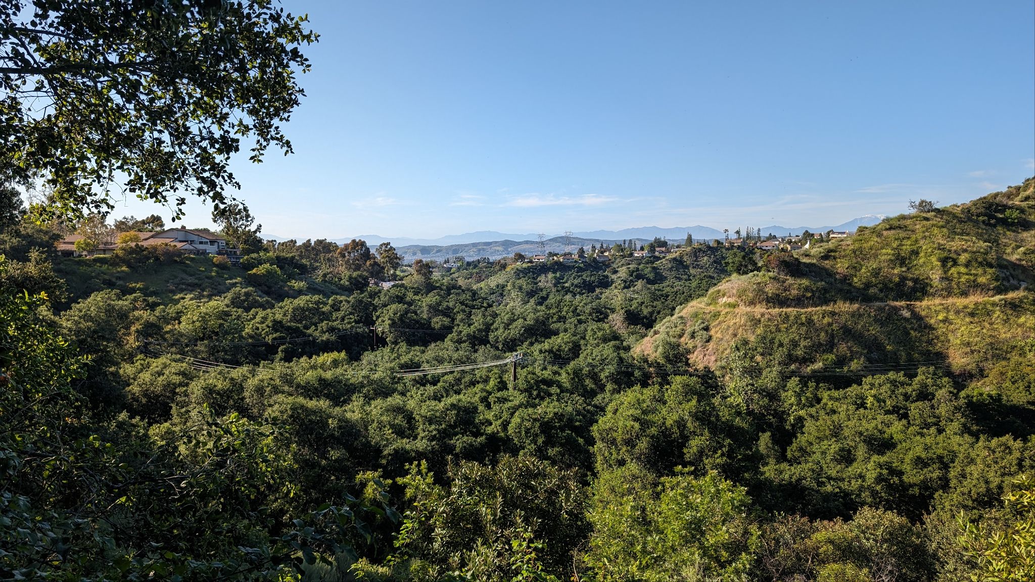
While the route of the Portolá Expedition took it through the west end of the village of Hutuuknga, the village’s territory likely extended to the east into Walnut Canyon in today’s Anaheim Hills. Here the canyons have oaks that would have provided acorns and other helpful materials to the people of the village. The Santa Ana River itself experienced flood and dry cycles that made it difficult for large stands of oaks to take root, so the villagers likely headed into the hills to gather acorns in the fall. The author has been able to piece together a likely trail that connected the site in this photo all the way to the village on Brea Creek.
On July 28, the expedition departed from Hutuuknga and proceeded north-northwest to today’s Brea on Brea Creek, probably in the vicinity of today’s Arovista Elementary School. There it encountered a smaller Tongva village than Hutuuknga, populated by several dozen people. That afternoon, one of the expedition’s journalists, Father Juan Crespí, recorded that they found there “a small, very green little canyon with a small pool of water and a large village of very friendly gentiles [unbaptized individuals], where we met a great many gentiles from the Dulcísimo Nombre de Jesús River River [Santa Ana River at the village of Hutuuknga] that we had just left.” He continued,
We made camp at a very grass-grown knoll next to here; at once on our arriving, the whole village came over without any weapons to our camp; there must have been around seventy of them, men and boys. They wished for us to stay at their village, but as it lacked convenience there, we withdrew to the knoll. We learned from these gentiles that the only water in this district was their little village pool, which could only serve for the people, and the mounts went unwatered this evening…We gave it the name The village of the small pool and valley of Santa María, Saint Martha. It can serve for only a ranch because of the lack of water; which is a pity, for there is a great deal of soil. (As I was beginning the Mass here at the Santa Marta Village a strong earthquake was felt though it did not last.)
Crespí later added,
I had forgotten to say that, ever since the spot called San Francisco Solano [Trabuco Canyon], we have been gathering that messengers are going out to the following villages to tell that we do not harm them but are good people, so that they are already notified, and quite fearless of us. I gave this spot the name of The village of the little pool and valley of Santa Maria, Saint Martha. A strong quake was felt here, though lasting less than a Hail Mary. (Crespí, A Description of Distant Roads, 323-325.)
Apparently the villagers also informed members of the expedition that “in the mountain range running along on the north [the San Gabriel Mountains], there are a great many bears.” (Ibid, 331) These were, of course, California Grizzly Bears, the last of which was killed in the wild in Orange County in Trabuco Canyon in 1908.
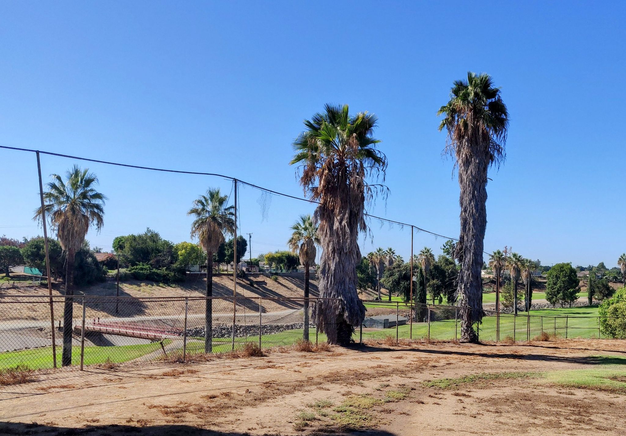
True to Southern California development, the likely site of the historic encounter between the Tongva Village along Brea Creek and the Portolá Expedition in 1769 is now a rock-lined ditch among low graded hills. The site today is located near Arovista Elementary School in Brea.
This association between Hutuuknga and the village on Brea Creek mentioned by Crespí is not trivial. Tongva villages shared in ceremonial and kinship ties and it was common for two or more villages to engage in ceremonies together. Tongva villages were also patrilocal, meaning it was common for women from one village to move to their husbands' villages. Since the missionaries later recorded every marriage at the mission, and often included the villages of origin of the bride and groom in the record, it is possible to determine which villages had kinship ties with Hutuuknga.
The following list was compiled from the registers of Mission San Gabriel from the Early California Population Project, a digital collection of all of the extant mission registers (for details on the methodology and approach to collecting these data, please message the author).
The most common village of origin for a spouse from the Hutuuknga was Hutuuknga itself. In other words, it seems that people from Hutuuknga were most likely to marry individuals from their own village. That said, the number was likely smaller because women who had moved to Hutuuknga may have stopped identifying themselves as being from their actual village of origin. If they were already married and then entered into a mission, they may not have identified their original village as their village of origin when getting married in the church. The same occurs today when someone moves to a new city and gradually begins identifying themselves as being from the city they live in rather than the city in which they were born.
In any case, the second most common village of origin for the spouse of an individual from Hutuuknga was Juyubit (20), followed by Jaysobit (16), followed by Guaspet (10). Juyubit was located on today’s Coyote Creek in the West Coyote Hills, Jaysobit was located in today’s Montebello, and Guaspet was located in West Los Angeles. The implication is that individuals from Hutuuknga tended to marry individuals from relatively closer villages, and fewer from villages relatively further away. There seems to have also been an important connection between all four of these villages along a west-to-east line connecting Los Angeles along the southern base of the hills stretching from Boyle Heights east to Santa Ana Canyon below the Chino Hills. Village locations can be found on the website “Tongva People,” but these locations are derived from a variety of sources, including John Harrington’s Notes at UCR.

Another important consideration is that recent scholarship suggests that villages are better conceptualized as territories rather than a population center in a specific location. Archaeologist Stephen O’Neill informed me that he noticed a pattern of village territories extending along a diameter of about seven miles (personal communication). The village of Juyubit along Coyote Creek in the northern portion of Buena Park was centered about four to five miles from Brea Creek. The entirety of the Coyote Hills, including all of the water holes throughout the low range of hills, may have been in the village territory of Juyubit. Various family groups (called clans) might occupy different watering places throughout the territory throughout the year.
There is also the possibility that the village on Brea Creek was a distinct village territory from Juyubit. Considering the marriage patterns of Juyubit, the following table emerges:
A similar pattern emerges in which there is a negative correlation between the distance a village is located from Juyubit and the number of marriages with individuals from those villages. The village of Totoavit was the most represented village among marriages of people from Juyubit. This village’s location is debated among archaeologists and anthropologists, but it may have been located in the nearby Chino Hills. The word “Totoavit” may have been pronounced Tot-Pa-Vit, translating roughly to “person from the waterstone.” This may refer to an important spring such as La Vida Mineral Springs or, perhaps, a rocky water hole somewhere in Brea Canyon. It's also possible that the village was the same as "Totavit," which is referred to in one of the mission registers as being on the Santa Ana River, although the author could not find the exact record. This could mean that the village was somewhere in the vicinity of Hutuuknga, perhaps a neighboring village up or down from the river. It may also be possible that the village on Brea Creek was itself part of the village territory of Totabit. This assertion is highly speculative, but the common marital connection between Juyubit and Totoavit is not.
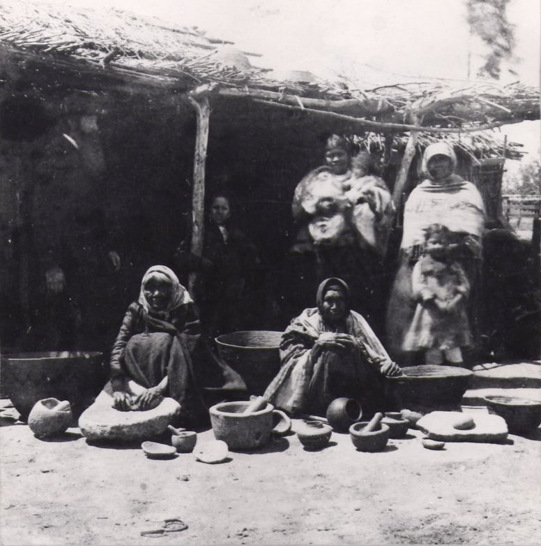
Tongva women are pictured here in 1883. The Tongva village in Brea was absorbed into Mission San Gabriel starting in the 1770s. One must imagine, however, that the beautiful basketry, steatite bowls, and various implements made by skillful Tongva artisans pictured here would have been commonplace in the village along Brea Creek. It is the author’s hope that more of their story can be told by a closer look at available evidence. With any luck, we will be able to begin naming some of the very individuals who lived in this village and piece together their stories. South Pasadena Public Library
A final note that the village along Brea Creek may have been an outlying camp of Hutuuknga. The author has been able to locate a trail connecting Weir Canyon near today's Anaheim Hills, and its abundant oaks, over the western ridge and down Walnut Canyon to the Santa Ana River near Bernardo Yorba’s ranch house site in Yorba Linda. It seems likely that the oaks along Walnut Canyon and Weir Canyon were the primary source of acorns for the people in the village of Hutuuknga (more on this in a future blog post). In any case, from the general area of the Bernardo Yorba village site, a trail headed northwest, perhaps roughly along today’s Imperial Highway, that went to the north side of the East Coyote Hills where Brea’s Tongva village was located. Another trail likely headed west from Bernardo Yorba’s ranch house site, roughly along Orangethorpe Avenue, where it intersected a trail probably in today’s Placentia that headed north. This was the trail taken by the Portolá Expedition. This trail headed to the east side of the East Coyote Hills, perhaps in the vicinity of today’s Craig Park, and then headed northwest where it reached Brea’s Tongva village. The village may have been near the intersection of the two trails, the one roughly following Imperial Highway and the other roughly following Orangethorpe Avenue before heading north from Placentia. In this context, it’s possible that Brea’s Tongva village site was actually a satellite camp related to Hutuuknga. It’s therefore possible that the reason the Portolá Expedition encountered people from Hutuuknga at the Brea Canyon village was because the two were part of the same collective of sites within Hutuuknga’s village territory.
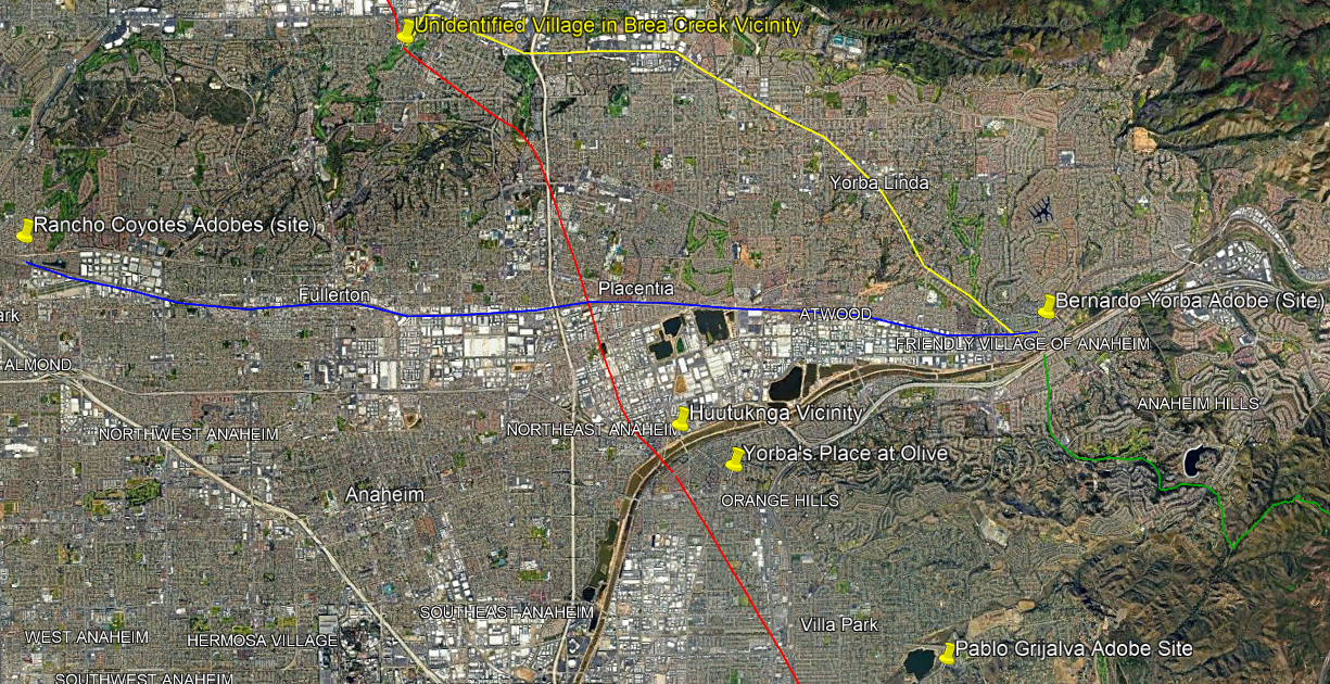
Brea’s Tonva Village was somewhere in the vicinity of the top-left part of this map. The red path is roughly the route of the Portolá Expedition in July of 1769. The village of Hutuuknga utilized the green trail at the bottom right to access acorns in Weir and Walnut Canyons that also connected to the Santa Ana River. Just across the river was the site of Bernardo Yorba’s adobe, which started being built in about 1834. The yellow trail left from the Bernardo Yorba site and roughly followed Imperial Highway to the vicinity of the Brea Village site. Another trail, in blue, headed west along Orangethorpe Avenue, intersected the red trail taken by Portolá, and ended up in the village territory of Juyubit, later near the location of the Rancho Coyotes Adobes.
The goal of this analysis is to identify the village name in Brea Canyon where the Portolá Expedition camped in 1769. While it cannot be said for certain, the site may have been a camp of the larger village territory of Juyubit, or possibly Hutuuknga or Totavit. If the name can be identified, it is also possible to determine the names of the people who were living in the village at the time of the expedition because is likely that many of the villagers ended up in the baptismal, marriage, and burial registers of Mission San Gabriel. It is the author's hope that this can be achieved so that we can better tell the story of this community.
Part 6: The Great Stone Church (A future post)
Part 10: Richard Henry Dana at Dana Point