Guaromo – the Story of a Village Territory and the Rancho Santiago de Santa Ana
Guaromo – the Story of a Village Territory

The holes in the rock above are called “morteros.” Near this rock are many oak trees that were the source of acorns, one of the primary foods of the people who lived in what is today Orange County prior to Spanish colonization in 1769. After gathering the acorns, women would gather on this rock to grind them into a powder during the process of preparing them for consumption. The deep holes pictured here suggest long-term settlement and utility of the resources in the area. This particular rock is located in the Santiago Canyon area and may be related to the village of Guaromo.
The Orange County historian Jim Sleeper once likened historical research to eating quail. “You wade through so much to wind up with so little,” he quipped. This is particularly true of the county’s Spanish and Mexican eras, spanning the years 1769-1848. Precious few resources relating to this time period have come down to us, many of which have yet to be translated from Spanish. While we can only dream of a detailed diary or interview with someone like Paat, an important Acjachemen leader at Mission San Juan Capistrano, or José Antonio Yorba I, the best-known early ranchero in the county, the reality is that historians must dig deeply into disparate sources to research the county’s early history. The purpose of this article is to illuminate the process of historical research into this time period and demonstrate how small discoveries can accumulate into telling the compelling story of a small Tongva village.
The story begins in 1769 with the Portolá Expedition, the first Spanish overland expedition through today’s Orange County. In the ensuing years, the villages of Indians in the surrounding area were impacted by the Spanish colonists, especially following the foundings of Mission San Gabriel in 1771 and San Juan Capistrano in 1776. The missions’ purpose was to convert the Indians to Catholicism and teach them trades conducive to an agrarian lifestyle. The Catholic Church required the missionaries to maintain records of the individuals living at the mission. Each baptism, marriage, and burial was recorded in separate books, called registers. Fortunately for historians, most of the registers from the missions and other colonial establishments in California are extant. Recently, the Huntington Library, with the aid of researchers such as Steven Hackel, have digitized these registers into a publicly accessible database called the Early California Population Project.
Rummaging through the database, I was interested to determine if any village of Indians on Santiago Creek was recorded in the registers. Doing so was complicated by the fact that the name “Santiago” routinely appears in reference to individuals from José Antonio Yorba and Pablo Peraltas’ Rancho Santiago de Santa Ana, which was formally established in 1810 in and around today’s Villa Park. Entries in the registers relating to the rancho were often of individuals from villages that were relatively far away from Santiago Creek. While this was true of entries from dates in the 1820s, I hypothesized that the earliest mentions of the rancho in the registers were the most likely to relate to individuals from nearby villages. In fact, one record of a baptism containing the place name “Santiago” predates the formal establishment of the rancho. On Sunday, June 19, 1808, a baby boy was baptized in the Great Stone Church of Mission San Juan Capistrano. While his name was not recorded, he was christened with the name Gerbasio (SJC Baptism #2879). The officiant, Father Juan Norberto de Santiago, recorded that he was from “Santiago, rancheria,” or the village at Santiago. This village seems to have been on Santiago Creek, which begins high between the peaks of “Old Saddleback,” runs out of the Santa Ana Mountains through today’s Irvine Park, and thence through Villa Park, Orange, and Santa Ana to its confluence with the Santa Ana River. While a couple of villages along the Santa Ana River have been previously identified, such as Hutuuknga near Olive in Northeast Anaheim/Placentia and Totabit further down river, no village on Santiago Creek has been positively identified. Unfortunately, Gerbasio’s baptism record does not indicate his village’s name.
While the Early California Population Project is an incredible resource, important details can often be gleaned from the original registers. I contacted Mission San Juan Capistrano’s archivist, Jennifer Ring, who graciously assisted me in viewing the original register and record. The entry reads:
“On the 19th of June, 1808, I solemnly baptized in the church of this Mission of San Juan Capistrano a child about a month old, son of gentile parents named Tomiaguaromovit and Jumucupijaran, from the Rancho de Santiago. I gave him the name Gerbasio. His godfather is Fabian, an Indian from this mission whom I informed of his spiritual kinship and the rest of his obligations. And in order to make a record of this, I sign - Fr. Juan Norberto de Santiago”
As it turned out, Gerbasio was recorded as being from the “Rancho de Santiago,” not from a village on Santiago Creek. While this was somewhat puzzling because the rancho was not yet formally established, it already existed in some form by 1808. Juan Pablo Grijalva, a retired alferez from the San Diego Presidio, had previously petitioned for the rancho in 1801. Grijalva and his sons-in-law, José Antonio Yorba and Pablo Peralta, are recorded as being in the Santiago Creek area by 1806, so it would not be surprising if locals already considered the rancho to informally exist when Gerbasio was baptized. Since Gerbasio was only a month old, it seems likely that his village was relatively close to the rancho, even if the record does not explicitly state that it was on Santiago Creek.
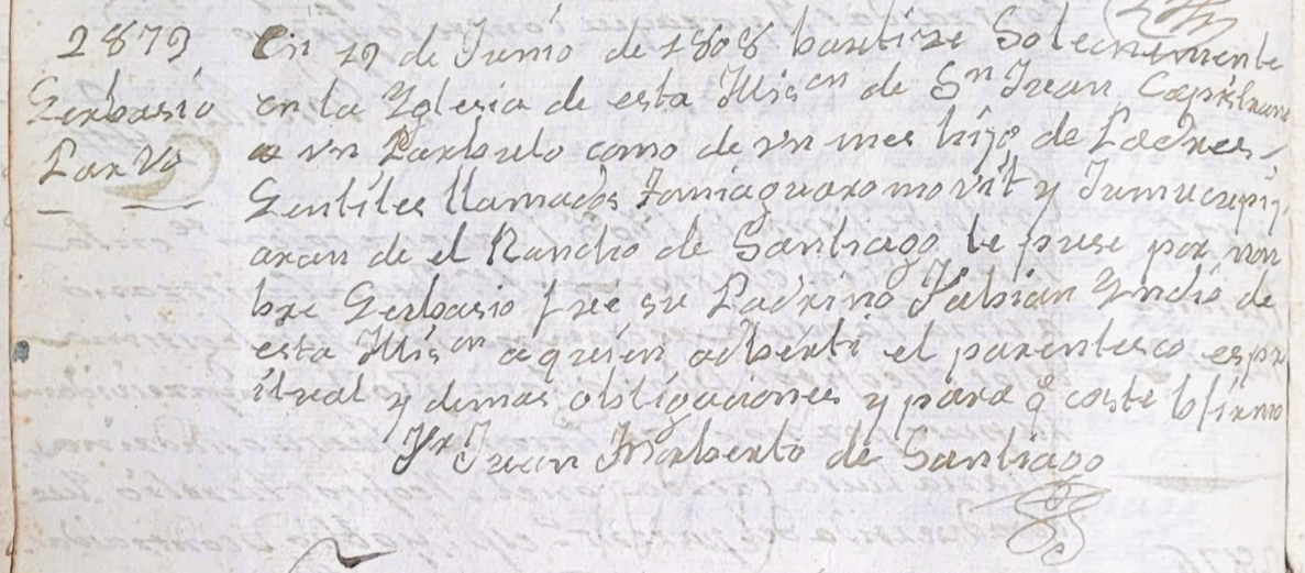
This is Gerbasio’s original baptism record in the baptismal register of Mission San Juan Capistrano. Written broadly in the middle is “Rancho de Santiago,” the first known reference to the Rancho Santiago de Santa Ana in the mission registers. (Courtesy of Jennifer Ring and Mission San Juan Capistrano)
Not finding further references to “Santiago'' from around the time of Gerbasio’s baptism record, I seemed to be at a dead end. But there were other strategies to consider before quitting. Sometimes records include references to relatives, so it was possible that Gerbasio could be linked to kin whose baptism, marriage, or burial records might preserve a village name that, by proxy, could then be associated with Santiago Creek. The process of tracking down Gerbasio’s family tree was arduous and soon produced a spreadsheet full of possible family members and multiple village names that were already associated with other locations. One of the villages that appeared in the search was Juyubit, which was located in the West Coyote Hills in Buena Park or Cerritos. This was somewhat encouraging because individuals from villages near one-another would often marry, suggesting that individuals from Gerbasio’s village on or near Santiago Creek married individuals in Juyubit. To this point, Gerbasio’s mother’s name was recorded in Spanish as “Jumucupijaran,” which may be phonetically related to “Hutuuknga,” a village on the Santa Ana River, or Puhú, a village in Black Star Canyon, which is a tributary of Santiago Creek. It’s possible that the suffix in her recorded name, “-ran” may be a phonetic match with the Tongva suffix “-vam,” meaning a woman. If this is correct, her name can be parsed into something like “Jumucupija” and “-vam,” or a woman from Hutuuknga or Puhú. This evidence may suggest that Gerbasio’s village was on Santiago Creek in the vicinity of the Santa Ana River or Black Star Canyon and located in today’s north Orange County. Unfortunately no unique village name appeared in my investigations of Gerbasio’s family that might suggest the name of his village in the "Rancho de Santiago" area.
At this point my interest in Gerbasio’s baptism record was put aside and I continued to research the general early history of the area. Months later, while reading The First Angelinos, The Gabrielino Indians of Los Angeles by William McCawley, I learned that the Indians in today’s northern Orange County, the Tongva, referred to a village leader as the “tomyaar,” as opposed to the word “Nu'' that was generally used for a village leader among the Indians of southern Orange County, the Acjachemen. This prompted me to look for words like “tomyaar” in the Early California Population Project database.
While searching for the string “tom,” I found a record of a baptism in which the child’s father’s first name started with “tomia,” which is similar enough phonetically to “tomyaar” to suggest he may have been a village leader. Glancing at the name of the baptized child I was surprised to see that it was Gerbasio! I was again led to this particular baptism record.
A possible explanation why Gerbasio’s father’s name referenced his being the village leader emerged. His full name in the baptismal record is “Tomiaguaromovit.” Assuming that the prefix “Tomia-” is actually “tomyaar,” the rest of his name could also be parsed for other hidden Tongva words. I had learned from previous research that the suffix “-vit” means “an individual from.” If these meanings of “tomia” and “-vit” are indeed correct, Gerbasio’s father’s name, or more accurately the phrase “Tomiaguaromovit,” may roughly translate into “the village leader of Guaromo.” Since Gerbasio was only a baby, perhaps Father Santiago asked someone present at the baptism, “who is the father?” The respondent may have misinterpreted the question, and instead of answering with a name, answered with the description “his father is the village leader of Guaromo.” This simple mistake may have unintentionally preserved important historical information. It’s also possible that Tomiaguaromo was simply his name which, as was not uncommon, referenced his village in his name.
Assuming that Guaromo was the name of the village on Santiago Creek, I collected all of the records containing variants of the name “Guaromo” from the database and color-coded married couples and their children. A sample of the baptisms that emerged is shown below:
The most interesting detail from the table is that six married couples and their children were baptized in February and March of 1812. The men were baptized on Friday, February 7, 1812 and most of the women the next day, with two others being baptized later on March 6. Splitting up baptisms between men and women was not without precedent, as Father Junípero Serra had done the same when he baptized individuals from the mission in 1778. Still, doing so was atypical.
This discovery prompted me to try to understand why the baptisms were split up. Searching the database for all of the baptisms at Mission San Juan Capistrano on February 7 and 8 yielded an astonishingly high eighty-one results! In addition, twenty-five of their children were baptized on February 6, resulting in a total of 106 baptisms in just three days. Furthermore, another twenty-three males were baptized on March 5, twenty-six females on March 6, ten others on March 7, and five more on March 8. Altogether there were 170 people baptized in this three-day cluster in February and four-day cluster in March of 1812. Since the population of the mission was about 1,200 at the beginning of 1812, these baptisms accounted for about a 14% increase in the mission’s population. It was extraordinarily rare for such a high number of baptisms to occur in such a short time. Typically, far fewer than one hundred baptisms were performed over an entire year.
I now needed to determine why such a high number of baptisms occurred over such a short period. Looking over the agricultural statistics in Zephryn Engelhardt's book on Mission San Juan Capistrano, I noticed that the mission had a record harvest of over 15,000 bushels of wheat, corn, and beans in 1811. Perhaps the Indians came to the mission for food. This would not have been unusual. One early missionary noted that Indians who entered Mission San Gabriel were “usually caught by the mouth.” (Bolton, Anza V. 4, pg. 181). Furthermore, surplus stores of food often prompted the missionaries themselves to seek out more Indians to baptize. This explanation alone, however, was found to be incomplete because the density of baptisms over such a short period of time in 1812 was not repeated in other years following large harvests. The mission’s second highest harvest in 1818, for example, was followed by a year with only 43 total baptisms, below the average of 65 per year over the mission’s history.
It’s also possible that the baptisms represent some kind of agreement or alliance between related villages. Almost all of the baptized individuals in February were from four villages: Juanipa, Guaromo, Pamechic, and Olalma. Father José Barona was the officiant on February 7 and Father Francisco Suñer officiated on February 8. Suñer noted that he and Barona had baptized a large group who had “repeatedly requested baptism.” The implication seems to be that the group came to the mission together, suggesting a connection between the villages. Unfortunately, Suñer did not record the village of origin for any of the females who were baptized. It’s possible that there was intermarriage between the individuals of all four villages. Since the Tongva and their neighbors were patrilocal, wives would generally move to their husbands’ villages so it is not clear which village each woman was originally from prior to marriage.
Little is known of the three villages of Pamechic, Juanipa, and Olalma. Anthropologists are left to scour the registers for phonetic similarities between village names and connect them to a location through a fortunate entry in the registers that mentions a known place name or through oral histories with descendants of the villagers themselves. More recently, research into intermarriages between villages has helped approximate the location of village names with unknown locations with those with known locations. Using these methods, the word “Pamechic” may be the same as “Pamaibit,” which refers to a person from Puhú high in Black Star Canyon (Acebo Dissertation, Pg. 229-237). This is interesting because there were undoubtedly strong connections between the people of Puhú and any village in Santiago Canyon, which could help explain why individuals from both Puhú and Guaromo may have gone to Mission San Juan Capistrano to get baptized at the same time. The villages of Juanipa and Olalma are more difficult to identify. The village of “Juanipa” may be a variant of “Wapijanga,” which may have been located along the Santa Ana River in the vicinity of today’s Prado Dam (SJC Baptism #3864 refers to this village as “Juaninga”). Olalama may be a village named “Pullala” on the San Luis Rey River below Pala, but this location is seemingly different than those of the other three villages and it would be somewhat surprising if its villagers did not seek baptism at the much closer Mission San Luis Rey (Camp Pendleton Report, Pg. 14-15, 30-31). There could also be a phonetic connection between “Olalama” and the village of Paxauxa, which was located near Norco, or the village of Passinonga (“-inonga” and “Olalma”), which was located in the Chino Hills. While nothing conclusive emerges from this analysis, it’s possible that there was a connection between Guaromo, Puhú, Wapijanga, and Paxauxa/Passinonga along an important route of travel from Santiago Canyon over the Santa Ana Mountains to the Santa Ana River near the Prado Dam. These villages may have served as an important conduit for goods traded between the coast and the interior and their inhabitants may have been connected through marriages.
While more research needs to be done on the individuals from these villages in the registers, another approach is to try to contextualize the baptisms within the history of the surrounding area at the time they occurred. The years 1801-1812 were important in the transition from the mission era to the rancho era in Orange County. As previously mentioned, the county’s first rancho, Rancho Santiago de Santa Ana, was officially permitted as a land concession to José Antonio Yorba I and Pablo Peralta in 1810 following Juan Pablo Grijalva’s original petition in 1801. Grijalva’s petition had been forwarded to the governor of the province by the commander of the San Diego Presidio, Manuel Rodriguez, who wrote that “there is not within a great distance of the place of Santiago any rancheria [village] whatsoever of natives.” Interestingly, Rodriguez then added that “neither of the two mentioned missions [San Gabriel and San Juan Capistrano] claims a right to it [Santiago] in conformity with the laws which assign to the missions or village of Christian natives two leagues [approximately five miles] in their environs.” (Caminos Viejos, 27). Rodriguez was referring to the Spanish Laws of the Indies that required that land within two leagues of a village of Indians who decided to be baptized and enter a mission would become part of the mission’s land holdings. The mission, after all, was intended to be a temporary institution that would eventually reappropriate its land back to the baptized Indians at the dubious point at which they had sufficiently been converted into productive Spanish Catholics. Rodriguez’ claim itself is somewhat dubious, considering that the concession’s boundaries were at the very least adjacent to the village of Hutuuknga and likely others along the Santa Ana River. His citation of the law, specifically the “two leagues in their environs,” may suggest that the villages in the area of the proposed land concession were not at such a “great distance” away as he initially claimed.
Grijalva apparently received a provisional concession and ran cattle in the area of Santiago Creek prior to his death in 1806. Early county settler and historian J.E. Pleasants located his adobe ranch house on Hoyt Hill, near the intersection of today’s Hewes Street and N. Rancho Santiago Boulevard in Orange. This location suggests that the cattle would have grazed in the Villa Park area, which was corralled between Santiago Creek to the south and east, the Santa Ana River to the west, and Anaheim Hills to the north. The tanning vats were apparently located across Santiago Creek from the adobe near the intersection of Taft Avenue and Cannon Street. Cattle grazing in the Villa Park area could be corralled northward where Santiago Canyon begins to narrow and then slaughtered near the tanning vats. Perhaps the Grijalva Adobe was built where it was in order to comply with the law because its location provided sufficient distance from the village of Hutuuknga, which was still populated at the time, near the bend of the Santa Ana River near Olive. The Yorba family later moved their primary residences to the Olive area, perhaps when the village ceased to exist after its population had been absorbed into the mission system.

A panoramic view along the Santiago Creek, circa 1890. The lone home in the center is the Hoyt House, which was built on the site of the original Grijalva Adobe. Across the creek to the right were the approximate location of the tanning vats. It was here that people from village territories in the Santa Ana Mountains (to the right) would access the Santa Ana River and the Pacific (to the left). (Courtesy the First American Corporation)
Considering that Gerbasio was only a baby and that the rancho was in a nascent state in 1808 at the time of his baptism, his village was probably located relatively near the Grijalva Adobe site. Using the adobe’s location as a reference point and assuming compliance with Spanish law, it was about five or six miles (approximately two leagues) down Santiago Creek to its confluence with the Santa Ana River, suggesting there was no village located along this stretch of the creek. Starting from the adobe site and heading up-canyon, it’s about five or six miles to Irvine Lake, suggesting there was no village along this stretch of Santiago Creek, either. It seems, then, that Guaromo was either located up-canyon from Irvine Lake or in Weir Canyon, which is a tributary that drains into Santiago Creek just below Irvine Lake.
Each of these general locations contain archaeological evidence of long-term occupation that may suggest one or both of them were, or were associated with, Guaromo. According to work conducted by the Pacific Coast Archaeological Society, an important site in Santiago Canyon was located near its confluence with Black Star Canyon with further sites located in Limestone Canyon. (PCAS Quarterly, Vol. 5, No. 1, July, 1969). This location was geographically advantageous for trade because it was on a route that went up Black Star Canyon to its well-known village of Puhú near Hidden Ranch and then over the Santa Ana Mountains into the interior. Villagers also had convenient access to the Santa Ana River plain through lower Santiago Canyon and the villages in today’s southern Orange County via a route through upper Santiago Canyon over a small pass near Whiting Ranch Wilderness Park. Another site of archaeological significance that possibly relates to Guaromo is in Weir Canyon. The canyon is filled with oaks and contains bedrock mortars indicating that it was at the very least a seasonal acorn gathering and processing site. Within the canyon, too, are a perennial spring and a nearby large rock with carvings, known as “Altar Rock,” that suggests a ceremonial significance (Jepsen, OC Roundup, 12/13/08). It’s also possible that the two sites had some kind of association with one-another because villagers at Hutuuknga on the Santa Ana River told the members of the Portolá Expedition that “the mountain people [possibly those in Weir and Santiago Canyons] wanted to take away [all their lands] from them.” (Brown, Crespí, Pg. 319). No village name has been associated with either of these two sites and each could have been the location of, or associated with, Guaromo.

This map from Google Earth shows the approximate locations of village territories relative to one another. The red path shows the approximate location of a common route over the Santa Ana Mountains, connecting Puhú to the Temescal Valley and possibly Guaromo towards the coast.
The geographical proximity of Rancho Santiago de Santa Ana to the archaeological sites in upper Santiago and Weir Canyons suggest that the latter may have been impacted by the rancho’s development. José Antonio Yorba wrote in 1809 that he intended for two of his sons, José Antonio II and Tomás, to take “three hundred head of cattle and the corresponding number of horses” to stock the land. Yorba also planned for his sons to take “the seed we contemplate sowing for our maintenance.” (Caminos Viejos, 30). After the land concession was finalized in July of 1810, the cattle were presumably added to those already brought by Grijalva to graze somewhere in and around Villa Park. This undoubtedly had an effect on the surrounding area that impacted the villages up Santiago Canyon.
While this story line is in itself compelling, it can be further analyzed in the context of how the Indians utilized the land. The Tongva people routinely traveled between village territories and acquired resources from the surrounding country. There were deep economic, cultural, social, familial, and ceremonial ties between villages. When the Portolá Expedition was camped on Santiago Creek near today’s Grijalva Park in 1769, its two missionaries explored a short way up-canyon. While doing so they encountered a stake weir built by Indians to create divergent channels of water and they later met “three or four gentiles [unbaptized Indians] near where we made camp.” One of the missionaries surmised that “there may be villages off in the distance across this wide-stretching plain, as the plain is of great extant,” suggesting that he did not see any indication of one near their camp (Brown, Crespí, Pg. 313). In any case, the implication is that Indians routinely frequented and utilized Santiago Creek far from their villages and right in the middle of what was later the pasture of Rancho Santiago de Santa Ana. The rancho affected their way of life even if the villages were located more than “two leagues” away. Over time, too, larger herds, the construction of irrigation channels for crops, and the needs of the growing Yorba and Peralta families increasingly impacted the surrounding country, further disrupting the lives of the people living in the area. It almost certainly didn’t take long for cattle to make their way up Santiago Canyon into the Santiago Oaks region and then into Weir Canyon and Irvine Park where the Indians lived.
Blending the context that villagers routinely procured resources far from their habitations with the previously examined high number of concurrent baptisms from villages that were connected over a large geographic area, perhaps there is a need to rethink the idea of an Indian “village.” The emerging picture may suggest that there was not a village of Indians insofar as we think of a central location where everyone lived. Instead, it seems there were family groups living together within a territory that had areas with relative advantages in access to water and resources that regularly, or periodically, had higher population densities. Inter-territorial relationships may have been far deeper than what is suggested by a centralized-village model of habitation.
Using an integrated village-territory framework, perhaps the establishment of Rancho Santiago de Santa Ana had a more significant effect on the region’s village territories than what might be suggested by its local impact by livestock in the Villa Park and surrounding regions alone. If, for instance, there was indeed a Guaromo-Puhú-Wapijanga-Paxauxa/Passinonga inter-territorial relationship over the Santa Ana Mountains that was further connected with other territories along the coast and inland, the Rancho Santiago de Santa Ana may have been perfectly situated to disrupt or break the social and economic interdependencies that allowed these village territories to thrive. Furthermore, if this interterritorial network existed as a conduit for goods to be traded between the coast and inland, it may have been one of the last of its kind. To the north of the Santa Ana River was the Rancho de los Nietos, which was established in 1784. The development of this rancho certainly affected indigenous trade routes to the important ceremonial and trade village territory of Puvuu’nga in today’s Long Beach near the Bay of San Pedro. It’s possible that Hutuuknga’s village territory was connected through intermediaries to Puvuu’nga, which may have been somewhat distinct from the Guaromo-Puhú-Wapijanga-Paxauxa/Passinonga route. This may help explain why one of the journals from the Portolá Expedition mentions that the people of Hutuuknga had a kind of conflict with the so-called “mountain people,” perhaps indicating that there were trade disputes causing tension between the village territories. The implication is that the people involved in the Guaromo-Puhú-Wapijanga-Paxauxa/Passinonga route may have wanted access to the Santa Ana River that was controlled by the people of Hutuuknga. That said, the so-called "mountain people" may have referred to Serrano or Cahuilla peoples, too. In any case, similarly to the south, Mission San Juan Capistrano was established in 1776 along an important trade conduit over the Santa Ana Mountains from today’s Lake Elsinore to Dana Point. The Rancho Santiago de Santa Ana was situated between them and potentially disrupted one of the last trade routes connecting village territories along the coast with villages inland with access to the mountain passes.
The importance of such an inter-territorial trade route would not have been lost upon enterprising rancheros. Yorba may have been one to take advantage. While today we associate the ranchos with stock raising and cattle hides (the so-called California Bank Notes), otter pelts were the primary trade item along the coast of California in the first decade of the 1800s. Otter pelts were commanding a high price in China, selling for between forty and a hundred dollars each. The rancheros themselves had little to no knowledge in hunting otters. They instead invested in relatively cheap items such as trade beads from Mexico to use as payment to Indians to obtain the hides. Trade beads could be used as a kind of substitute for the shell-bead monetary system used by the Indians. (Quote Marie Duggan’s book on Santa Barbara). Yorba may have understood that Rancho Santiago de Santa Ana's location allowed him to arrange with freelancing Indians to hunt otters, possibly from villages such as Genga or Lopuuknga in the Newport Beach and Costa Mesa areas. If so, he entered into existing economic interdependencies between village territories as simply another contractor paying for goods from the coast. His efforts were highly successful. In December of 1806 he sold 156 otter pelts to an American ship anchored in San Pedro Bay for $1268 pesos. This single transaction was a huge sum of money, more than double his annual salary when he was a sergeant in the military. To add to his fortune, he sold another 143 otter pelts to the same ship just seven months later for another $1070 pesos. (Logbook of the Mercury, SBMAL). While it’s unknown if he sold otter pelts to any other trade ships, the high profits likely prompted him to continue the enterprise. In any case, Yorba only expressed his intention to “stock the land with three hundred head of cattle and the same number of horses” two years later, in 1809. (Rowland, Donald E, Countiana, Pg. 10).
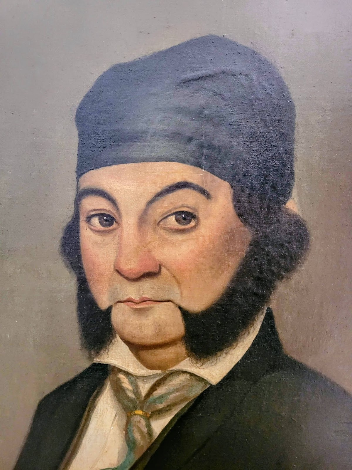
We do not have any portraits of Jose Antonio Yorba I. We do, however, have two portraits of one of his sons, Bernardo Yorba. This portrait of Bernardo was painted in the early 1850s by Henri Penelon.
The emerging story suggests that Yorba and the inhabitants of the Rancho Santiago de Santa Ana may have sought out local villagers for labor. I was now prompted to look for every reference to Rancho Santiago de Santa Ana in the registers for Missions San Juan Capistrano and San Gabriel. My findings are below:
Indians in Registers from Rancho Santiago de Santa Ana
Key:
A strong link to village names with a prefix of pam- or paim- followed by a suffix of -vit (Tongva suffix meaning an individual) or -mey/-mei (Luiseño meaning an individual) may indicate an important connection between the rancho and the village of Puhú in the valley of Páamajam, located in today’s Hidden Ranch in upper Black Star Canyon. The mixing of Tongva and Luiseño languages relating to the village indicates its importance among multiple linguistically distinct peoples, connecting it to a wide region in Southern California. It’s possible that its importance grew during the Spanish colonial era as a center of resistance among peoples avoiding the mission system. It must have also had a strong influence from Payόmkowichum (Luiseño), Cupeño, and Cahuilla villages connected to the Temescal Valley, behind the Santa Ana Mountains from the coast. This again suggests Puhú in the valley of Páamajam as being an important conduit between the coast and points inland. The historical territories of the people recorded at the Rancho Santiago de Santa Ana further point to more of a connection east to the San Gorgonio Pass and the Colorado River than the Mojave through the Cajon Pass to the north. This may lend support to the possibility of trade disputes between a route over the Santa Ana Mountains, which included Guaromo and Puhú, and a route along the Santa Ana River through the village of Hutuuknga mentioned by one of the journals of the Portolá Expedition. It’s possible that the people of Hutuuknga had deeper connections with village territories to the north that connected to Cajon Pass prior to disruption by Spanish Colonization.
Another potentially important discovery is an alternative spelling of Guaromo as Corobonabit (G for C, m for b). Searching the registers for “Corobonabit” again yielded numerous entries, this time at Mission San Gabriel. Similar to the high density of baptisms from Guaromo at Mission San Juan Capistrano in February, 1812, a total of twenty-nine individuals from Corobonabit were baptized on April 12-13, 1811. Over the same two days, forty-seven individuals were baptized from Paimavit. Together, the total number of individuals baptized from Corobonabit and Paimavit was seventy-six, which was the vast majority of the eighty-six baptized over the course of two days. This was again an atypically high number of baptisms and strongly suggests an important link between Guaromo and Puhú. This further implies that the people of Corobonabit/Guaromo largely entered into the mission system over two days in April, 1811, at Mission San Gabriel and three days in February, 1812, at Mission San Juan Capistrano. The timing of these baptisms coincides with the formal establishment of Rancho Santiago de Santa Ana. It may also suggest that the missionaries intentionally split up the baptisms at two separate missions in order to spread the extra demand on food resources at each mission. The baptizing event at Mission San Juan Capistrano between village territories may have been strategic on the part of the missionaries to help facilitate social tranquility by having a large number of individuals from historically Tongva territory enter into a mission with a largely Acjachemen (Juaneño)/Payόmkowichum (Luiseño) presence.
The link between Guaromo and Puhú was further demonstrated via marriages. Out of the forty marriages with either the bride or the groom being recorded from Corobonabit (or a variation of Guaromo), at least twelve and up to fourteen (>30%) were with individuals from Paimavit. No other village linked to Corobonabit via marriage appears more than five times (<15%). Furthermore, the link between Corobonabit and Puhú was particularly strong at the time of the high number of baptisms at Mission San Gabriel. Between 1804-11, ten out of the seventeen recorded marriages were between individuals from Corobonabit and Puhú. Unfortunately it’s unknown how many of the marriages recorded at Mission San Juan Capistrano in 1812 were between individuals from the same two villages because Fr. Suñer did not record the origins of the women he baptized. Examining the marriages in the years following the large number of baptisms related to Corobonabit/Guaromo at Missions San Gabriel and San Juan Capistrano in 1811-12, however, shows that only three out of twenty-one marriages linked Corobonabit and Puhú. This may suggest that the two villages were more closely associated prior to the bulk of the population entering into the mission system. Thereafter it’s possible that the Guaromo/Puhú was further populated and diversified by individuals resisting entrance into the mission system. The recorded marriages are shown below:
If Corobonabit and Guaromo are indeed the same, it’s possible that Gerbasio’s parents were baptized at Mission San Gabriel. In fact, two individuals were recorded as the “Captain of Corobonabit” on April 18, 1811. The first was Tucutuoyt (SG Baptism #4727) and the second was Tameyainet (SG Baptism #4729). Neither of these names seem convincingly related to Gerbasio’s father, Tomiaguaromovit. That said, Tameyainet does have the prefix “tamey-,” which is similar to “tomia-,” possibly meaning “village leader.” Tameyainet’s wife was recorded as “Topiabam,” which is significantly different from Tomiaguaromovit’s recorded wife, Jumucupijaran. It should be noted that these baptisms occurred three years after Gerbasio’s, so there may have been a change in the captain of the village.
Another important discovery emerged from one of the baptism records at Mission San Gabriel from Corobonabit. Two babies were baptized on April 17, 1809. The first was recorded as being from Corobonabit and his brother was recorded as being “from the same village that is in the direction of San Luiz.” This almost certainly refers to Mission San Luis Rey. From Mission San Gabriel there were two primary pathways one could take to Mission San Luis Rey. One roughly followed today’s 5 Freeway through Orange County to Mission San Juan Capistrano and then proceeded along the coast to Mission San Luis Rey. The other went east from Mission San Gabriel and roughly followed the 71 and 15 Freeways south through Temescal Valley and thence to the San Luis Rey River Valley. The missionary who recorded this baptism, Fr. Zalvidea, had been at Mission San Gabriel since late 1806 and had thoroughly explored the area in the northern San Gabriel Mountains and the Cajon Pass. That said, there is no record of him at Missions San Juan Capistrano, San Luis Rey, or San Diego until after 1809, suggesting that he may not have had a thorough understanding of the geography south of Mission San Gabriel. Still, this baptism record indicates that Guaromo may have actually been located on the north or east side of the Santa Ana Mountains, not in the Santiago Creek area. If so, it’s somewhat surprising that Gerbasio’s parents would have brought him from so far away to Rancho Santiago de Santa Ana. That said, modern concepts of distance may not align with the people living in these villages at the time.
While there is a lot more research to be done, at this point a possible sketch of the story of Guaromo can be summarized. Guaromo may have been a village territory in the Santiago Creek area, perhaps encompassing archaeological sites along Santiago Creek as well as tributaries such as Weir Canyon. It could have also been located directly over the Santa Ana Mountains in the northern Temescal Valley. Guaromo had an important territorial link to Puhú in the valley of Páamajam in today’s Black Star Canyon, which itself was along an important corridor of travel and trade over the Santa Ana Mountains. These two villages shared familial, ceremonial, cultural, and economic ties. With the establishment of Mission San Juan Capistrano to the south, Mission San Gabriel and Rancho Nieto to the north, the conduit of trade between Puhú and Guaromo may have increased in importance, connecting trade and village territorial networks between the coast and inland areas by the first decade of the nineteenth century. When the Rancho Santiago de Santa Ana was organized in the 1801-1812 period, the village territories of Guaromo and Puhú were significantly impacted. By 1806, the ranchero José Antonio Yorba may have taken advantage of existing trade networks between village territories to profit off of the otter trade. When the rancho was formally established in 1810, its developments and increasing population further impacted the region. Missionaries likely increased their efforts to persuade the inhabitants near the rancho to enter the mission system. In April, 1811, many from Guaromo and Puhú were baptized at Mission San Gabriel, the primary mission among the Tongva village territories. Following a record harvest in 1811, it’s possible that the missionaries arranged for a large number of individuals from village territories stretching across the northern Santa Ana Mountains to be baptized at Mission San Juan Capistrano in February, 1812. Thereafter, the northern Santa Ana Mountains may have become a center of resistance among peoples living in inland areas, especially through the Temescal Valley and upper Santa Ana River.
Which takes us all the way back to Gerbasio. He was only a newborn at the time of his baptism at Mission San Juan Capistrano. We don’t know why his parents apparently presented him to the earliest inhabitants of Rancho Santiago de Santa Ana. Perhaps he was sick and they were seeking assistance. Perhaps the earliest developments of the rancho had already impacted their way of life and they were looking for solutions. In any case, Gerbasio died just months later. His death was undoubtedly devastating to his parents, affecting his family and the people in his village. His singular story reminds us that every one of the individuals in the mission registers represents a full human story. Standing in the cemetery of Mission San Juan Capistrano, it’s worth remembering that Gerbasio is buried there among thousands of others.
Despite my efforts, I haven’t been able to conclusively determine Guaromo’s location. Jim Sleeper’s comparison between historical research and eating quail seems particularly true while doing research using the mission registers. That said, the journey is the scholarship. With any luck, we can uncover the stories of people like Gerbasio and the people of Guaromo. And Gerbasio's burial record has an alternate for his father's name; Sucaroumovit. Back to eating quail...
As an addendum, if you want to continue the story of Puhú, check out my article on the first recorded ascent of "Old Saddleback."

The village site of Puhú nestled high in the Santa Ana Mountains. This site may have had important connections to a village territory down canyon, possibly named Guaromo.
Part 6: The Great Stone Church (A future post)
Part 10: Richard Henry Dana at Dana Point