The Trabuco Adobe - The Oldest Adobe Outside of Capistrano in OC?
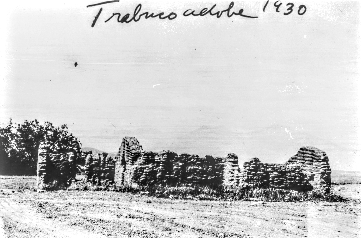
The Trabuco Adobe was likely one of the earliest outposts of Mission San Juan Capistrano. Notice the oak along the creek to the left, and “Old Saddleback” faintly visible above the right side of the adobe. Notice, too, the far left portion of the adobe that was added later, with the original front triangular entrance still visible just to the right of the tree.
The Trabuco Adobe
The Oldest Adobe Outside of Capistrano in OC?
Mission San Juan Capistrano is the most famous historical site in Orange County. For tourists, the mission is seemingly confined to the mission’s extant buildings in the city of San Juan Capistrano, which are also the oldest in the county. But during the mission era the mission had dominion over territory throughout Orange County. County wanderers sometimes run across sites far from the mission that were once connected to it. One of the best known is the Trabuco Adobe site in O’Neill Park.
The Trabuco Adobe was one of Mission San Juan Capistrano’s primary outposts. The site was originally named during the Portolá Expedition in July of 1769 when a soldier lost his blunderbuss, an early shotgun-like firearm known in Spanish as a “Trabuco.” The site was adjacent to a moderately-large (~70 people) Juañeno village that was phonetically spelled by the Spanish as Alauna. It was also located along the most common route of travel used by Spanish colonists during their first decade in California (from 1769 to about 1779). The site is just eight or so miles up Trabuco Canyon from the mission itself.
Standing alongside the Trabuco Adobe’s ruins today, one can be transported to the site’s distant past. Here Acjachemem vaqueros, after a long day of shearing sheep, rested to eat tortillas and get a drink of water from the nearby creek. A mule driver prepared the oxen hitched to the carretas filled with fleece to make the several mile trip down canyon to the mission. As the shadows grew longer and the cool ocean breezes flowed up the canyon, one of the mission’s foreman made note of how much fleece had been collected and considered what needed to be done the next day.
Just how far into the past these scenes occurred, however, has yet to be determined. The Trabuco Adobe’s date of construction is somewhat obscure. Historian Jim Sleeper suggested that it may date back to as early as 1806, and historian Phil Brigandi entertained the possibility that it may date to a little earlier. These suggestions certainly fit the timeline of the mission, which reached the height of its prosperity in the first decade of the nineteenth century. But they were also determined using circumstantial evidence without elucidating or suggesting anything particularly special about the adobe’s history or purpose.
A reexamination of the available mission era documents can help demystify the adobe’s story. While very few records are extant, it turns out that much more of the Trabuco Adobe’s history may be available in the historical record than previously known. The story these records tell helps shape a better understanding of the adobe and its function during the mission era. They also suggest a date of construction earlier than any other adobe in Orange County outside of the city of San Juan Capistrano.
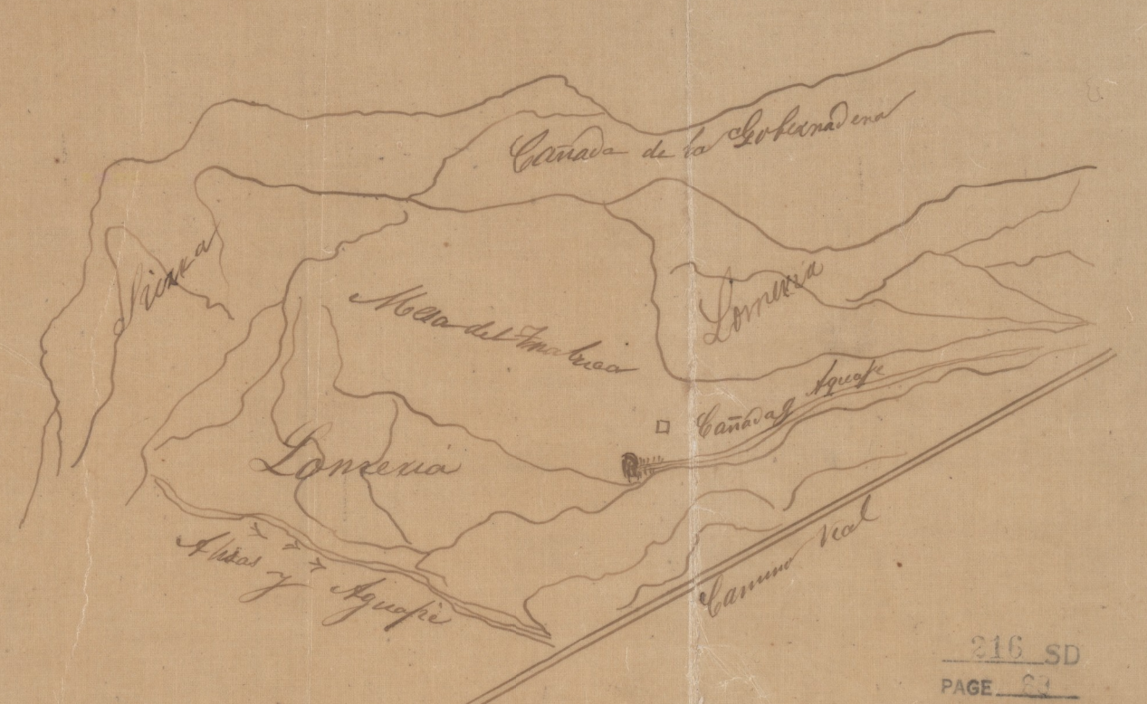
The Trabuco Adobe appears on a map of the Rancho Trabuco that was probably drawn in the 1840s when the rancho was established, or in the 1850s was the United States sought to legally establish rancho boundaries through the Land Commission. The Trabuco adobe appears as the small square middle-right on the “Mesa del Trabuco.” The location of the adobe suggests that the mesa was the primary pasture and the adobe was located towards the narrowing of the canyon on the road back to Mission San Juan Capistrano.
Mission Outposts
Like all missions during the Spanish colonial era in California, Mission San Juan Capistrano controlled a vast territory beyond the mission itself. Since missions were intended to be proto-villages populated by the local Indians that would later become typical Spanish settlements, they were organized around the primary economic pursuits of the time; agricultural developments and the raising of livestock. Desirable areas within about a half-to-a-full days’ ride on horseback from the mission that were suitable for either farming or animal grazing were thus formally developed as outposts by the mission for such purposes.
Very broadly, these outposts fell into one of three categories: sitios, ranchos, and estancias. Sitios (sometimes referred to as estancias), or mission ranchos, were locations within a mission’s jurisdiction where there was a small adobe, typically with just a small number of rooms, that was seasonally occupied during sheep shearing season in spring and/or during the cattle roundups in late spring or summer by the vaqueros (cowboys) and the mayordomo (foreman) of the mission. Ranchos usually had both crops and livestock and were maintained by a specific individual and his family who lived on-site. Estancias (sometimes referred to as asistencias) were sub-missions that had permanent Indian residents and a chapel.
In December of 1828, not long before the secularization of the missions in the early 1830s, Lieutenant Santiago Argüello of the San Diego Presidio wrote a report on the sitios, ranchos, and estancias of the missions under the jurisdiction of the San Diego Presidio. In the case of San Juan Capistrano, Argüello recorded four such sites, each categorized as a sitio. They were (listed from north to south):
Santa Ana - its adobe was likely today’s Diego Sepúlveda adobe in Costa Mesa
San Joaquin - its adobe was located in the San Joaquin Wildlife Sanctuary in Irvine
Trabuco - the ruins of the adobe are in O’Neill Park
San Mateo - the adobe was located on the northern bank of the mouth of San Mateo Creek where it drains into the Pacific on the site of La Casa Pacifica, or the “Western White House”
Besides these, it’s possible that three or more other similar sites had adobes for seasonal or temporary residence. These include San Juan Hot Springs, Mission Vieja (located in San Juan Canyon a couple of miles up from the mission today), and Niguel (located in Laguna Niguel). There may have been others, but these account for most of the outposts within the jurisdiction of Mission San Juan Capistrano.

This photo, probably taken in the 1930s, clearly shows “Old Saddleback” to the left, with its twin summits Modjeska and Santiago peaks. Notice the flat landscape, perfect for pasture and herding animals.
A New Mission Rancho in 1788
In the early part of 1788, Father Mugártegui, who had been the lead missionary at Mission San Juan Capistrano since shortly after its founding, wrote to the commander of the San Diego Presidio, Lieutenant José de Zúñiga, asking permission to establish a “rancho” somewhere within the jurisdiction of the mission. At the time, San Juan Capistrano's agricultural developments and gardens were located near the mission and along San Juan Creek. With a growing population, it seems, the missionaries intended to expand their livestock operations elsewhere. Zúñiga apparently denied the request on the grounds that Mugártegui had to first seek permission from Governor Pedro Fages in Monterey. After being informed, Fages wrote to Mugártegui on June 10, 1788 that he did not “oppose the establishment of a rancho for the mission” and that the reason he needed to be informed was so that he could “provide support in its establishment.” Fages had been in San Juan Capistrano in February of 1787 and probably had some idea that Fathers Mugártegui and Fuster planned to establish an outpost.
The purpose of the mission rancho authorized by Governor Fages in 1788 was almost certainly to open new pastures for livestock. The mission’s statistical records show a major increase in the number of livestock from 1788, the year the mission rancho was authorized, and 1790, the year after the mission rancho was probably developed. The number of sheep, for instance, reported at the mission in 1788 was 2,507 and in 1790 the number had grown to 4,700. Similarly, the number of cattle increased from 1,360 in 1788 to 2,328 in 1790. All of these new animals required new pasture and it would make sense if the Trabuco Mesa and surrounding hills were used for grazing purposes. By contrast, the mission’s agricultural production was stagnant over the same period. The total amount of corn that was planted decreased from 9.5 fanegas in 1788 to 6.67 fanegas in 1790. While the total amount of wheat planted increased from 43 fanegas in 1788 to 57 fanegas in 1790, the mission’s annual report for 1790 indicates that the wheat was planted at “mission vieja [about two miles up San Juan Canyon from the mission]” and towards “la playa [meaning “the beach,” probably referring to the land adjacent to San Juan Canyon between the 5 Freeway to the east and Del Obispo St. to the west].” Taken together, these statistics strongly suggest that the purpose of the mission rancho authorized by Governor Fages in 1788 was to open up new grazing lands for livestock.
Increasing the number of sheep at the mission was purposeful. Clothing and blankets for use by neophytes of the mission were two of the largest expenses for the missionaries. The wool from the mission's sheep supplied the raw material to make fabrics for various purposes. In 1790, Fathers Vicente Fuster and Norberto de Santiago reported that in order “to benefit from the wool of the sheep of this mission, and to reduce costs [for clothing and blankets], three looms have been set up” to weave the “white and black wool” into “fabrics for various tasks.” They also reported that “some Indians continue to learn to weave,” indicating that artisans from the Naval Department of San Blas, which was responsible for supplying the California missions by sea, were perhaps already taking on neophyte apprentices.
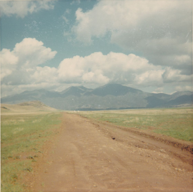
This image of the Trabuco Mesa in the 1970s shows “Old Saddleback” above what is now approximately Antonio Parkway near today’s Tijeras Creek Golf Club. At left is “Lone Hill,” famously climbed by members of the Portolá Expedition in 1769.
The Santa Ana, San Joaquin, or San Mateo?
By analyzing the available evidence, it’s possible to determine the most likely of the four sitios permitted by Fages as a mission rancho in 1788.
Of the four sitios recorded in Santiago Argüello’s report, it seems unlikely that it was either the Santa Ana or the San Joaquin. In 1817, the missionaries requested of the governor “lands at Los Bajios de Santa Ana and Las Bolsas on which to pasture mission cattle.” The “Bajios de Santa Ana'' probably refers to the San Joaquin sitio and “Las Bolsas” likely refers to the Santa Ana sitio. Historians have considered that this request suggests that the Diego Sepúlveda adobe (on the Santa Ana sitio) was built as early as 1817. Since the San Joaquin and Santa Ana sitios were relatively further away from the mission than the Trabuco or San Mateo sitios, a relatively later date for their establishment makes some sense. But such a late date also seems to be contradicted by the missionaries’ claim in a report from 1827 that the mission had grazed cattle “[o]n the other side of the [Santa Ana] river [seemingly the location of the Santa Ana sitio]...for more than thirty years,” suggesting a need for a ranch house as early as the 1790s. While it’s unclear why the missionaries would request permission in 1817 to graze cattle on land they were already using, it may have had something to do with boundary disputes with land concessions that had been given to the Nieto and Yorba families, who had established ranchos on either side of the Santa Ana River. In any case, since the missionaries’ report in 1827 claims that mission cattle had been grazing on Las Bolsas (the Santa Ana sitio, including today’s Diego Sepúlveda Adobe) for “more than thirty years,” it seems the very earliest date for the establishment of the Santa Ana sitio was the early-to-mid 1790s and is therefore less likely to be the mission rancho permitted by Fages in 1788.
By contrast, the missionaries provided no additional information concerning the establishment of the San Joaquin sitio in their 1827 report, making it somewhat more likely to have been the mission rancho permitted by Fages than the Santa Ana. It should be noted, however, that a report written in 1806 following an expedition by soldiers pursuing an otter-hunting vessel from the United States referred to Newport Harbor, where the vessel was anchored, as “the place called las Ranas,” or “the frogs,” which was the Spanish place name for the back bay of Newport Beach. Typically “las Ranas” was applied to the marshy area much further inland towards Red Hill, suggesting that the soldier expedition had no better place name than “las Ranas” to apply to what is now Newport Beach. Had the San Joaquin sitio and its adobe on a bank above the back bay already existed, it seems likely that the soldiers would have used it to identify the location of the vessel, not “las Ranas.” Indeed, by the time of the rancho era in the early 1840s, the back bay was known as the “Bolsa de San Joaquin,” referring to the original mission sitio. On the balance, this evidence doesn’t seem to support the San Joaquin sitio as the mission rancho permitted by Fages in 1788.
The other sitio that Governor Fages may have referred to in his letter to Father Mugártegui in 1788 was San Mateo. Like the Santa Ana and the San Joaquin, however, there is evidence to suggest that it wasn’t. The first appearance of “San Mateo” in the mission registers was not until February 8, 1793, five years after Fages permitted the establishment of a mission rancho. In the intervening years, neophytes had been baptized from the village of Pange, adjacent to what was later the San Mateo Adobe, but never with a reference to “San Mateo.” This seems especially odd because San Mateo Canyon was certainly named by 1777. Furthermore, Alfonso Yorba, a local San Juan Capistrano historian in the first half of the twentieth century, claimed that the San Mateo Adobe “overlooked the mission grain fields in the river valley below and to the east,” suggesting that the purpose of the site was to grow crops. As mentioned earlier, however, there is strong statistical evidence that the purpose behind the mission rancho authorized by Governor Fages was to open up new grazing lands for more livestock. If the San Mateo mission rancho really was established in part to grow grain, the mission statistics show that the amount of grain that was planted dramatically increased from 80 fanegas (each fanega is about 1.58 bushels) in 1794 to 177 fanegas in 1800, coinciding with the place name “San Mateo” showing up in the mission registers and possibly suggesting the date of its establishment in the early-to-mid 1790s.

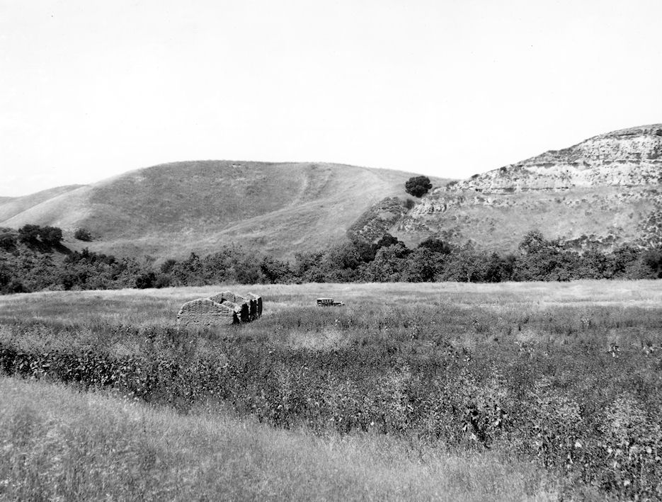
This image of the ruins of the Trabuco Adobe in 1967 show how quickly the adobe bricks deteriorate without roofing to protect them from the rain. The portion still standing in this image is now protected behind a wooden structure. This portion of the adobe is the original adobe entrance. Notice the water working its way up the walls.
The Trabuco?
There is a good case to be made that the mission rancho permitted by Fages in 1788 was the Trabuco. While the name “Trabuco” was already a common name for the site and canyon among the Spanish by the time Mission San Juan Capistrano was established in 1776, the first time it appears in the mission registers occurred in the baptism of an eight-year-old girl from Alauna on January 20, 1788, the same year the mission rancho was permitted by Fages. The girl’s origin was recorded as the “Ranchería del Trabuco.” Her baptism was the first conducted by missionary Father Norberto de Santiago’s after his transfer to the mission.
The Trabuco Adobe sits on the Trabuco Mesa, a long tableland that parallels the east side of Trabuco Creek. The mesa provided plenty of pasture, which is consistent with the apparent purpose of the rancho permitted by Fages in 1788. Following the mission era, both cattle and sheep grazed on the mesa late into the nineteenth century, suggesting a similar purpose during the mission era. While dry farming was achieved on the mesa in the early decades of the twentieth century, the absence of mission era zanjas or acequias (irrigation channels) suggest that the area was indeed used for pasture, not farming. All of this evidence points to the Trabuco Rancho being a livestock operation that is consistent with the increase in livestock in the mission’s statistics following the establishment of the rancho in 1788.
The Trabuco Adobe itself may also show up in the mission records. In 1789 the missionaries of San Juan Capistrano wrote that they had constructed “a room 15 varas long and 5 varas wide [each vara is about 33 inches, or approximately 41’ by 14’], roofed in tile” and “a corral 60 varas square for the cattle.” While this room and corral may not have been located at the “rancho” established the year before, there is good reason to consider that they were. A kiln for firing tejas, or roof tile, was built at the mission in about 1787, and the Trabuco Adobe certainly had an adobe roof, as roof tile fragments are strewn about the ruins and some of its original roof tiles were used in the restoration of the Serra Chapel in the early twentieth century. The annual reports don’t typically mention the construction of a single room building, since most of the buildings at the mission itself were composed of multiple rooms, and the potential association between the room and the corral (they’re listed in succession in the report) may suggest that they were built together somewhere other than the mission site. Measurements of the dimensions of the Trabuco Adobe were recorded by the Works Project Administration (WPA) and published as ground plans in 1936. The WPA report gives the length of the two eastern rooms (there were three rooms in the Trabuco Adobe in later years, the westernmost room being a later addition) as 22’4” and 16’8” with an approximate 22+” divider between them that was perhaps added later. In total, the length of the two eastern rooms was a little less than 500 inches, which is almost exactly 15 varas in length. The width of the building, including the two adobe walls, is given in the report by the WPA as 21’. Subtracting the widths of each wall, which are each recorded as approximately 36”, the room's width was about 15 feet (180 inches), or a little more than 5 varas in length.
There is also evidence that the Trabuco Adobe was adjacent to a corral, as may be suggested in the mission's annual report from 1789. William Hartnell, an inspector for the Mexican Government reporting on the state of the missions in 1839, recorded that the “place called Trabuco” had “the ruins of a house and a wooden corral one hundred varas square.” It should also be noted that the missaries recorded in their annual reports the construction of a corral mostly made of adobe “but the rest made of palisade” in 1786 and of an adobe corral in 1793, while the corral in the 1789 report is not specified to have been constructed of adobe.
It should also be said that the Diego Sepúlveda Adobe may have also originally measured 15 by 5 varas, although the additions and changes in the floor plan make it much harder to convincingly measure to those dimensions compared to those of the Trabuco Adobe. As previously mentioned, it seems more likely that the earliest date for the construction of the Diego Sepúlveda Adobe was sometime in the 1790s, not 1789. While nothing is known to exist of either the San Joaquin or San Mateo adobes, Alfonso Yorba indicated that the San Mateo Adobe was “a large, tile-roofed adobe of three or four rooms,” perhaps suggesting that it was larger than the relatively small building measuring 15 by 5 varas in the mission’s annual report from 1789. While the evidence isn’t conclusive given that two of the sitio adobes were apparently entirely demolished, the Trabuco Adobe certainly had dimensions that closely conform to the adobe measuring 15 by 5 varas in the 1789 report.
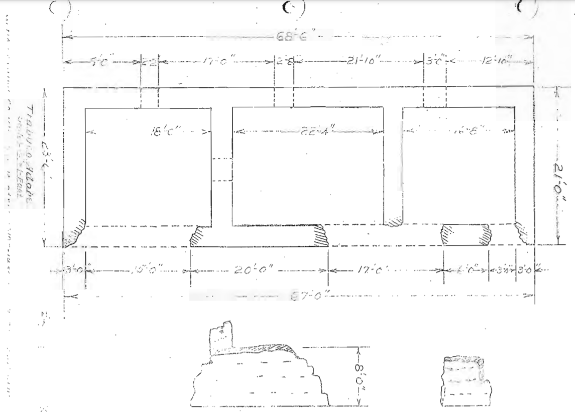
One of the WPA’s projects in the 1930s was a survey of all of the adobes in Orange County conducted by C.E. Roberts. The resulting report contains a floor plan of the Trabuco Adobe with all of its dimensions.
Life at the Adobe
The Trabuco Adobe was built in the middle of the grazing lands of both mission cattle and sheep. A trail led down to the creek nearby, which, along with a small spring near the adobe itself, provided the residents water. Across Trabuco Canyon from the adobe is a conspicuous outcropping of light-colored sandstone that served as a marker for the location of the adobe to travelers heading up canyon towards the outpost. Far into the distance, Santiago and Modjeska Peaks tower above the canyon to the north, with Trabuco Mesa’s grazing lands lining the creek towards them.
Adobes at such mission outposts were typically very simple. They usually had only two rooms, one that “served as the entry and living room, and the other as a sleeping room.” Historian Phil Brigandi considered these adobes to generally be used for the “vaqueros (cowboys) to get out of the weather.” Such was likely the case, and the dark rooms of the adobe, lit only by small windows, the light through the open door, and the candles on the table, served at most to give the workers and visitors shelter to eat and sleep. The mission’s carpenters fashioned simple furnishings, probably out of imported wood from Northern California, that probably included simple chairs, a bench or two, and a table. The beds were at best stretched hides raised slightly above the floor by small wooden stakes.
The outpost was managed by a mayordomo, or foreman, who in the early days was one of the so-called gente de razón, a Spanish colonial term indicating someone who had legal status as a Spanish Catholic outside of the mission systemd. The mayordomo likely made use of the adobe and table inside to maintain the account book. Indian cowboys and sheepherders, referred to simply as vaqueros, likely lived nearby in dwellings like those used prior to the arrival of the Spanish. Indian translators, called corporales, who had an advanced grasp of the Spanish language, often communicated the orders of the mayordomo to the vaqueros.
The vaqueros were a special class of neophytes. In 1787, Governor Fages wrote to the Father President Fermín Lasuén that Indians should not be permitted to ride horses as a defense against their ability to challenge the Spanish colonists. Lasuén wrote back that there was simply no one besides the neophytes who could do the work of attending to the mission livestock. As a result, the vaqueros often received special treatment from the missionaries and mayordomos. They were dressed in the best clothing of the time, wearing pantaloons, boots, a hat, and even leather jackets of buckskin. During roundups, they would ride the surrounding countryside along the mesa to drive the animals towards the adobe and its corral. The corporales also recorded every animal that was branded by adding notches to a stick, called a bali. Each of the bali’s four sides had a symbol representing an animal category, such as a bull, cow, heifer, and ox. Each time “an animal was branded, a notch was cut into the sharp edge of the stick.” The matanza, or cattle slaughter, took place near the adobe. There they would remove the hides and load them on simple wood carts. Similarly, the sheep would be sheared, and the usable wool would be sorted and placed onto the carts. Once full, the carts were drawn by oxen back to the mission where further processing of the raw materials would take place.
The oral history that was passed down and collected by Father Saint John O’Sullivan at Mission San Juan Capistrano in the early twentieth century gives some impression of life at the adobe. The mission’s bell ringer during Father O’Sullivan’s tenure was José Gracía de la Cruz, better known as Acu. Acu remembered that “just west of the ruins [of the Trabuco Adobe] at a distance of about ½ mile are some paderones, high cliffs with markings of strata. They said that music used to come from them just at sunset. It was very sweet music made by the drum, flute, and violin. But the Indians and Mexicans and all heard the music many times but no one ever knew who made the music.” Such instruments were in common usage at the mission churches since their beginnings. One can imagine that after a long day in the fields rounding up cattle or sheep, or finishing the matanza or sheering, that the vaqueros were exhausted. As the chilly winds blew up canyon from the coast, perhaps they heard the sweet music emanating from cliffs as they prepared for their ride back home at the mission.
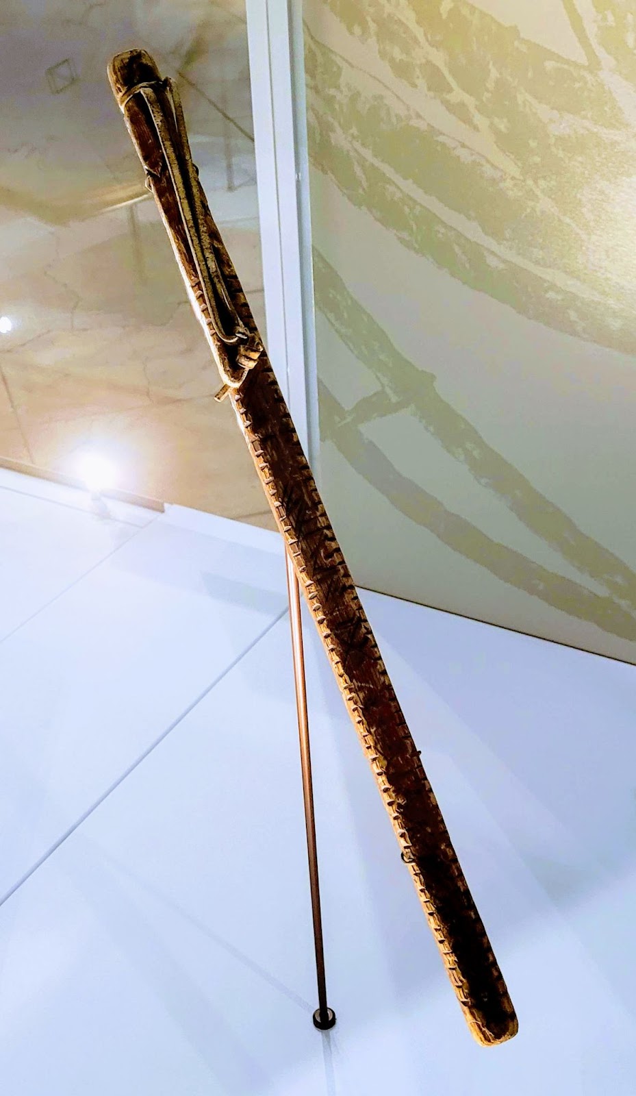
An example of a bali used to count livestock is displayed in the Natural History Museum of Los Angeles.
The Trabuco Adobe’s Story
On the balance, this evidence suggests that the Trabuco mission rancho may have been formally established by Fathers Mugártegui and Fuster in 1788 and the Trabuco Adobe and an adjacent corral for cattle were possibly constructed in 1789. The mission rancho permitted by Governor Fages in 1788 coincides with an expansion of Mission San Juan Capistrano’s pasture lands, which are plentiful along the Trabuco Mesa. The absence of irrigation ditches on the Trabuco Mesa suggests that the Trabuco mission rancho was indeed used for pasturing the animals, not farming. The Trabuco Adobe also has dimensions that conform to an adobe built in 1789, the year after Fages permitted the establishment of a mission rancho. The Trabuco area was also the earliest known to the Spanish colonists of the four sitios in Argüello’s report of 1828 and it was easily accessible from the mission, making it perhaps a stronger candidate to have been developed first. Usage of the name “Trabuco” in the mission’s registers coincides with the mission rancho established in 1788 and precedes any of the other sitio’s names in the registers by five years. None of this evidence is conclusive, but it certainly suggests that the Trabuco Adobe was built as early as 1789 and the Trabuco Mesa and the surrounding hills were used as pasture land for cattle and sheep, the latter of which supplied wool that was woven into blankets and clothing for the neophytes and other Spanish establishments in California.
This view of the Trabuco Adobe likely taken in the 1930s shows the adobe ruins, Trabuco Creek (lined by trees in the middle distance), and the cliffs where at sunset it was said that “sweet music made by drum, flute, and violin” was heard by the vaqueros along with the onshore winds blowing up canyon, perhaps exhausted after a long day in the fields. (Courtesy the First American Corp.)
Part 6: The Great Stone Church (A future post)
Part 10: Richard Henry Dana at Dana Point